Working for bus passengers in and around Cambridge
Author: CBGbusUsers
Cambridge Area Bus Users
• seeks to represent – and campaign on behalf of – bus passengers in and around Cambridge;
• is independent of any political party.
Stagecoach’s citi2 buses will again serve Parkside from Sunday 14th April 2024.
The Volvo electric buses allocated to the citi2 route will serve Parkside
Many years back, before the advent of the Cambridgeshire Guided Busway, Stagecoach’s citi2 route (towards Milton) stopped on Parkside, opposite the Fire Station. Then, as now, in the opposite direction (towards Addenbrooke’s) buses stopped at Mortimer Road (NaPTAN 0500CCITY370).
Cambridge Area Bus Users wondered, with the 905’s move to Drummer Street bus station releasing Parkside, Bay 16 (NaPTAN 0500CCITY476) whether this stop would be available for use by the citi2. So we asked. The response surprised us.
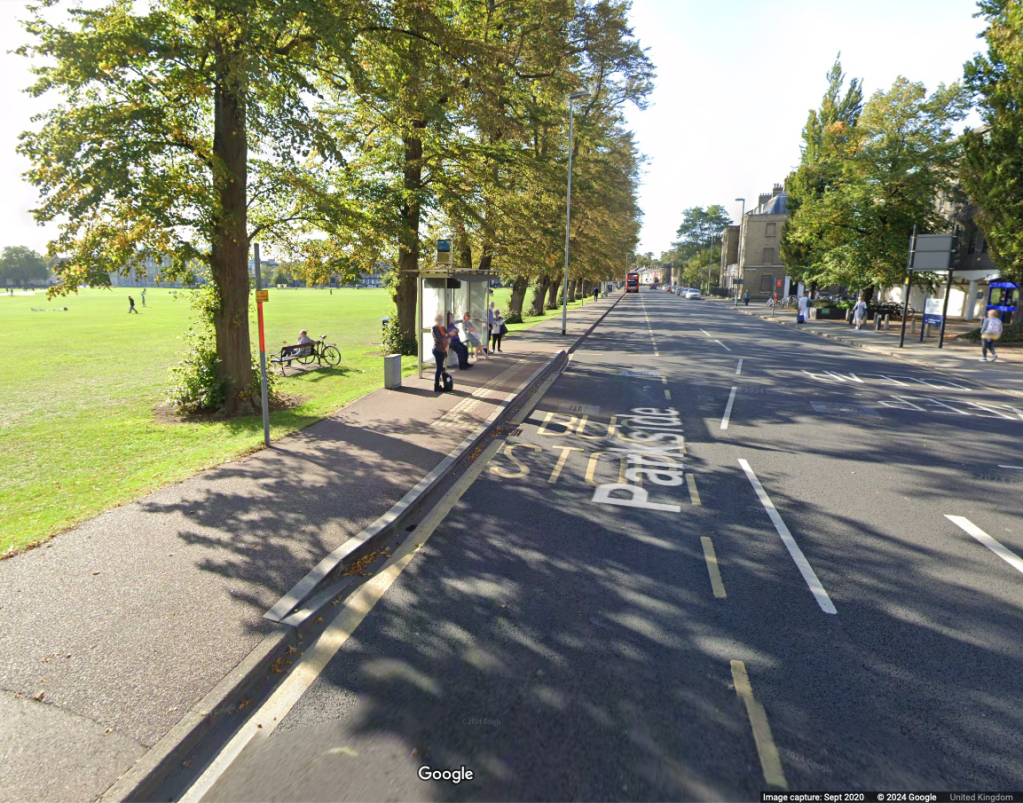
Rather than using Parkside, Bay 16, the citi2 buses will pick up and set down at the stop opposite the Fire Station – now known as The Busway, Parkside (0500CCITY117) – which was previously used.
The Busway Parkside (0500CCITY117) from Google Maps
Cambridge Area Bus Users welcomes this development as the stop…
will be useful for Grafton Area shoppers, with a largely traffic-free walking route to Fitzroy Street, via Melbourne Place and Eden Street;
will be of some use for passengers to/from Anglia Ruskin University in the evenings and weekends (when the access from Mackenzie Road is closed);
will serve students, staff and visitors to Parkside College.
Members and others will no doubt have seen reports in the local media about work on the Southern Busway between Hills Road bridge and the Addenbrooke’s Spur Junction, based on this press release – Guided Busway works begin to allow closure to be lifted, 06 February 2024 – from Cambridgeshire County Council.
Since February 2022, a section of the Guided Busway in one direction has been closed between Cambridge Railway Station and the Cambridge Biomedical Campus. The inbound only track (closest to the maintenance track) was closed to allow for a temporary fence to be installed without reducing the width of the path used by pedestrians and cyclists. This measure has severely impacted the busway service and connections to key employment and health facilities.
The temporary fence was installed whilst we waited for an independent safety review and following ongoing communications with the Health and Safety Executive (HSE) and as part of our continuous review of safety on the busway.
The busway and the maintenance track (foot and cycle track) are currently programmed to re-open on Saturday 30 March.
Cambridge Area Bus Users wondered about speed limits, and asked some questions
The questions, and responses from a Cambridgeshire County Council Highways officer are shown below.
What northbound speed limit is proposed on the guideway?
The proposed speed limit will be the 30 mph restriction that was in place before the installation of the safety barrier, and which is in place on all of the operational parts of the southern section
Will this be mandated by the HSE, or at the discretion of Cambridgeshire County Council?
There has been no reference made by the HSE as to a required speed limit. As mentioned previously, the pre-existing speed limit will be in place when the closed guideway re-opens.
What is the justification for the 15mph limit on northbound buses leaving the guideway towards Station Place?
The speed limit was lowered to 15 mph several years ago, due to the increasing numbers of pedestrians, cyclists and other non-motorised traffic in this area. There is a transition area directly at the northern end of the Cambridge-bound guideway where cyclists cross between the carriageway and the maintenance track in both directions, and where there is more interaction with pedestrians using the maintenance track and the footpath towards Station Place. In addition, there is subsidiary traffic entering and leaving the same are via the access from the Obsidian development adjacent to the Busway.
Could this be raised to a 30mph limit?
While it would be possible to raise the speed limit to any required level, the Council would not wish to exponentially increase the risk of a collision with non-Busway traffic, and the increased likelihood of major injury or death arising from such an increase. The current speed limit allows bus drivers more time to react to what can be unpredictable movement by non-Busway users.
What is the justification for the 30mph limit on the southbound guideway to the Addenbrooke’s spur junction?
The speed limit across the entire southern section was reduced to a blanket level of 30 mph some years ago, largely in response to the increased numbers of pedestrians, cyclists and other non-motorised traffic arising from the construction of new housing developments, and the expansion of the Biomedical Campus at Addenbrooke’s Hospital. The speed limit is also in keeping with those in place on the road network around the Busway corridor.
Can the southbound guideway – separated from the cycleway/footway/maintenance track by the northbound guideway, and the new fence – revert to the original 56mph limit?
Whilst it would be possible to raise the pre-existing speed limit to the original speed limit of 56 mph, there is no compelling case to do so. The maximum theoretical transit time gained through increasing the speed limit to 56 mph over this limited distance would be approximately 62 seconds, assuming that a bus entered and left this section of guideway at that speed. However, as the speed limits at either end of the section would be lower, there would be a period on entry where a bus would need to accelerate to the maximum permitted speed, and subsequently a period where the bus would need to decelerate before exiting the guideway to match the speed limit in place at the end of the guideway. These actions would reduce the gains in transit time well below the theoretical maximum.
In addition, and possibly of a greater impact , all buses that use the southern section have their speeds regulated by on-bus control systems using GPS-based geo-fencing. The accuracy of these systems does not have sufficient accuracy to allow for differing speeds on the guideway tracks that are immediately adjacent to each other.
If the 30mph limit is mandated by the HSE, will the County Council and Combined Authority press the HSE to allow the limit to be raised?
As stated above, the HSE have not made reference to any required speed limit in the southern section. The rationale for the 30 mph has already been addressed in my response regarding your question on the 30 mph limit on the southbound guideway. As I have already stated, there is no compelling case to increase the speed limit, and the technology in use to regulate bus speeds currently in use would preclude a separate speed limit for one section of guideway in this section.
Whilst a 15mph limit is required for southbound buses at the point of entry to the southbound guideway, why does this apply from the junction with Station Place?
The reasons are the same as stated above, in response to your question regarding the 15 mph speed limit for buses leaving the northbound guideway.
Could this apply only from the overhead hanging height limit warning signs before the Hills Road bridge, with the 30mph limit applicable in Station Place continuing up to this point?
As outlined above, given the levels of non-Busway traffic using the area, there would be little to gain by doubling the speed limit for buses over such a short distance, and any gains in transit time would be negligible. The area between Station Place and the height restriction barrier is where large numbers of pedestrians cross the roadway from the station side to reach the path that eventually joins the maintenance track adjacent to the guideway south of Hills Road bridge, and an increase in the speed limit would increase the likelihood and severity of a collision between buses and non-Busway traffic.
We look forward to the re-opening and, even with the lower speed limits in both directions, buses will, once again be able to avoid the traffic congestion on Hills Road (which the Greater Cambridge Partnership and others seems reluctant to tackle).
The images displayed here are from BusAndTrainUser the retirement activity for Roger French OBE DL MA, former MD of Brighton&Hove Bus Cº, a blogging site which we are pleased to promote.
Long Road Sixth Form College are running an event regarding bus services across Cambridgeshire and surrounding areas, on Tuesday 5th March 2024 5:30pm – 7:00pm.
Since the changes to bus routes in October 2022, many local communities have found their bus service to be less than satisfactory; an issue that is particularly impacting young people accessing a variety of educational, work and social opportunities. We want this to change.
Share your questions and feedback with Mayor Dr Nik Johnson of Cambridgeshire and Peterborough Combined Authority (our Transport Authority) who are raising additional Council Tax to fund more bus services, and representatives of bus companies Stagecoach, Whippet and Stephensons of Essex, who will be able to talk about any of their bus services; giving young people and their families the opportunity to share their feedback and get their questions answered.
Important information for attendees:
You must book 1 ticket for each person attending the event, including parents/carers.
On-campus parking is available. Please use public transport or car-share where possible.
Long Road Sixth Form College will be taking photos for use in their marketing materials and social media. If you would not like to be photographed please alert their photographer(s) when you see them, or move out of shot.
Stagecoach are rerouting service 905 within Cambridge from 18th February. This will mean a change to the stopping arrangements in both directions.
The 905 will no longer serve stops in Victoria Avenue and Maid’s Causeway. Instead it will head into the city centre down Bridge Streeet and Jesus Lane (calling at both stops along this route) before terminating at Drummer Street Bus Station (Bay 7). The same route is followed by trips towards St Neots and Bedford. Passengers for the Grafton Centre, therefore, will need to use the Jesus Lane stops. And the service will no longer be exiled to the Parkside terminus.
Cambridge Area Bus Users (CABU) have been asking for this service to return to Drummer Street for a while (the layout was unsuitable for the coaches that previously used to operate the service). Since the former X5 was split into two portions and double deckers introduced on the 905 there seemed to be no good reason for the service not to return to the Bus Station. The issue appears to have been the allocation of Drummer Street bays on FRAND (fair, reasonable and non-discriminatory) terms. The resolution of this issue to the benefit of service 905 passengers is welcomed by CABU.
[The digital timetable data currently loaded into journey planners and the like shows inbound services continuing to call at the Northampton Street stop, whereas there’s no corresponding stopping point shown on outbound trips. This seems illogical, but attempts to determine what’s actually going to happen on February 18th have so far failed to elicit a clear response. Sorry!]
Subsequent correspondence with Stagecoach East and with transport officers at Cambridgeshire and Peterborough Combined Authority have confirmed that both stops on Northampton Street will be served.
The Cambridge-Saffron Walden Sunday service 132, operated by Myalls, is being revised from 31st December. The changes aren’t major, and are designed to provide a little extra recovery time should services encounter congestion. The net effect is that most departure times are 5-10 minutes later than at present.
It’s worth mentioning that this service provides the only direct journeys of the week between Cambridge/Trumpington and the Imperial War Museum at Duxford. It also serves Duxford village, Ickleton, Great Chesterford and Littlebury.
Thanks are due to Essex County Council for providing news of the changes, via its Bus Passenger News. At the time of writing the new timetable seems to be available only on the Travel Essex website: https://www.travelessex.co.uk/search-for-a-timetable/timetable/356 (Traveline and Bustimes both still display the old timetable, but that will doubtless change shortly).
Centrebus are making minor changes to the timetable for service 26 (Cambridge-Royston) with effect from Monday 20th November. These affect the evening peak timetable, in an attempt to improve the reliability of late afternoon and evening peak services.
Further changes to a small number of Stagecoach routes (and the introduction of one new service) are taking place with effect from Sunday 29th October.
Citi 1. A new early morning trip will leave Arbury at 4.55 a.m., Monday to Saturday, heading to Fulbourn.
Citi 2. Minor changes are being made to the weekend timetable.
PR5 (Milton Park & Ride). In addition to minor timetable changes, Landbeach will now be served every 30 minutes on outbound journeys (Landbeach passengers travelling to Cambridge know to board outbound services and travel via Waterbeach).
City Sightseeing. The winter timetable returns, with minor changes.
25A (new service). This is a new service operating a small number of early morning and mid-evening trips, Monday to Saturday, between Trumpington Park & Ride and the Biomedical Campus. This service, like the 25 (which it supplements) will operate via Addenbrooke’s Road, not the Busway.
LInks to these revised and new timetables are available from the Stagecoach website.
Here are some details from the launch event at West Hub, JJ Thomson Avenue, Cambridge, CB3 0US, on Friday 29th September 2023.
One of the nine Mellor Sigma 12 buses serving the U1/U2 routes This is one of two with personalised registration marks Note the cameras which replace traditional exterior mirrors
We don’t intend to duplicate reports from elsewhere, but add a few details about the vehicles and the attention to detail which has gone into the new vehicles and the re-imagined routes.
Reports from the University and the news media, give the overview and key details of the new U1/U2 7-day/week service from Girton Corner to the Cambridge Biomedical Campus. (Yes, the Biomedical Campus is served on Sundays, and Newnham gains a Sunday bus service to the rail station and the Biomedical Campus.)
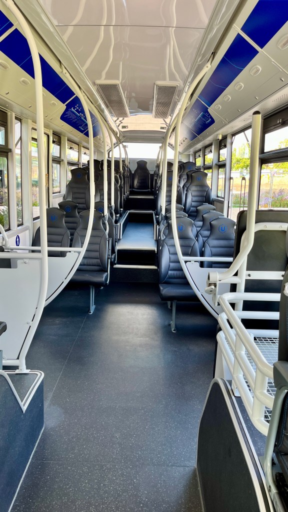
The nine Mellor Sigma 12 buses – designed, engineered and fitted out in the UK – have two wheelchair/buggy bays (each with three tip-up seats for when not fully occupied by wheelchairs or child buggies) and ten highly-accessible, fixed, high-back seats on the low-floor section, forward of the raised area to the rear, under which some of the batteries are housed.
Interior of one of the Mellor Sigma 12 vehicles showing ten highly-accessible, fixed, high-back seats on the low-floor section, forward of the raised area
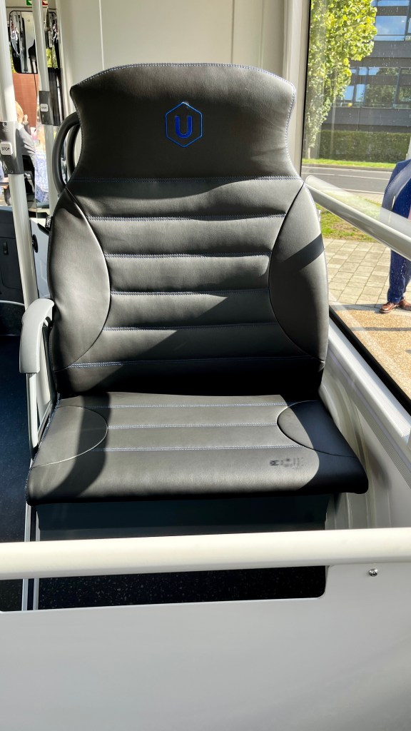
Above the front wheel arches are three slightly-wider single seats designed to accommodate a parent with a small child.
One of the three slightly-wider single seats designed to accommodate a parent with a small child
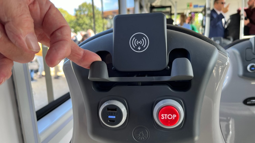
Smartphone getting low on its charge? The University, Whippet and Mellor have the solution…
You can charge up wirelessly, or with your USB-A or USB-C cable Note, also, the STOP button on the seat-back and the button for the reading lamp
Passengers benefit from clear audio-visual announcements for the direction of travel (eg ‘Towards Girton Corner’) and the next stop, comfortable high-backed seats (ten of which are accessible on the low-floor section), two wheelchair/buggy bays, multi-way phone charging, a STOP button on every seat-back, and even a reading-lamp to help decipher those all-important marginalia.
Drivers have the benefits of external cameras at the front (replacing traditional mirrors) and at the rear, an AI-assisted hazard detection system, fully adjustable driving-seat, steering wheel and a dashboard which adjusts with the wheel.
The enhanced audio-visual announcements mentioned above are only part of the mission to remove anxiety from bus travel. The installation of seat-back STOP buttons in addition to more traditionally-located buttons help those with hidden disabilities. But these features are only part of the integrated mission.
West Hub bus stop, towards Cambridge Biomedical Campus
All stops have been updated with a printed timetable in a weatherproof case, and a bus stop flag which shows the direction of travel. Wherever possible, bus stops have many more passenger-friendly features.
The West Hub bus stop shown in the foregoing photograph, has a shelter with integrated seating, good hard-standing, a printed timetable in a weatherproof case, e-paper real-time passenger information, and gives easy access to the bus for wheelchair users. The bus stop flag reads ‘towards city centre, rail station & Biomedical Campus’.
This stop fulfils all of the criteria for quality Bus stop infrastructure in our joint briefing paper with Living Streets, Cambridge.
A feature to give a smile
The other of the two vehicles with personalised registration marks
Recently, Roger French OBE DL MA, BusAndTrainUser, visited Whippet as part of his fortnightly A to Z of bus and train companies. Read the blogpost here: W is for Whippet.
Too much bus stop infrastructure is poorly designed for queueing, boarding and alighting, especially disadvantaging passengers using wheelchairs, walking-aids, and parents with buggies.
Cambridge Area Bus Users has received numerous complaints about bus stop islands (‘floating’ bus stops). Some members are of the view that this type of bus stop should not be installed. However, as with all highway infrastructure, there are good examples and poor examples. (Unfortunately, we are still looking for a good example of a bus stop island in or around Cambridge.) And, just to scotch an ugly little rumour, the design and implementation of bus stop islands is not overseen by Camcycle. (We would like to know who does oversee the design and implementation of bus top infrastructure.) Poor design of bus stop islands creates problems for cyclists, bus passengers, and pedestrians alike, but particularly disadvantages people with disabilities.
And sub-standard bus stop infrastructure is prevalent in traditional stops, too.
But let’s start on a positive note, with some good-quality, recently-installed bus stop infrastructure.
Standard bus stop: good design & infrastructure
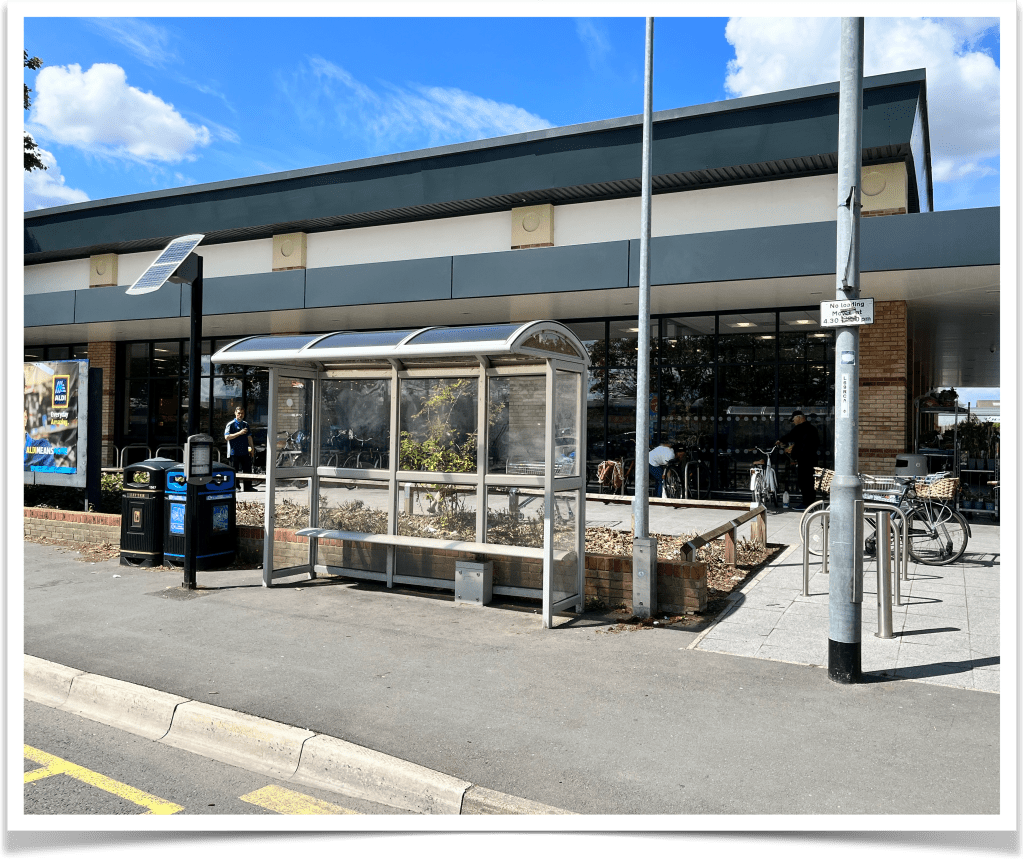
Stanley Road (outbound) 0500CCITY165 (outside Aldi, Newmarket Road, Cambridge)
Good points
The shelter, with integral seating, is set back at the edge of the highway boundary.
A bus stop flag has been mounted on an adjacent street-lighting column.
RTPI, of e-paper type, is installed close to the shelter at the upstream end.
There are no obstructions for passengers boarding/alighting.
Well-sited litter bins do not obstruct pedestrians.
Overall installation gives good access to accommodate a ‘reference wheelchair’ (DfT guidance) of 1.20 m length and deploying the associated 1.20 m manually-extended bus-mounted wheelchair ramp.
Point for improvement
There should be a lockable case for printed route/timetable information.
Standard bus stop: poor design & infrastructure
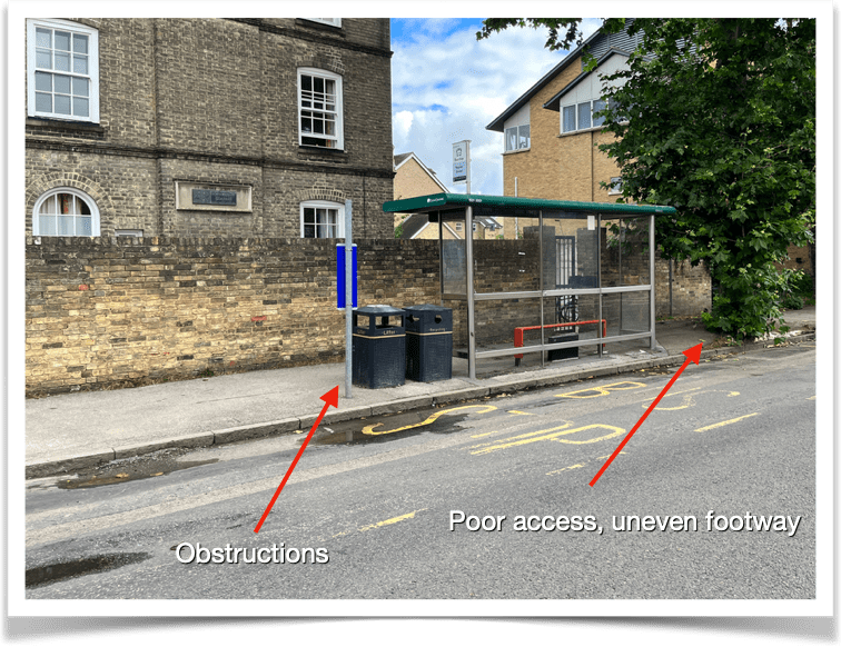
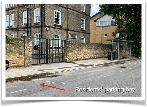
Napier Street (outbound) 0500CCITY102 (Newmarket Road , Cambridge)
Deficient points
The shelter is adjacent to the bus stop carriageway-markings. However boarding from the downstream end would be difficult because of a nearby tree, which ‘bushes’ near its base in the growing season.
At the upstream end of the shelter boarding/alighting is obstructed by a litter bin, a recycling bin and a redundant bus stop pole with no flag.
A nearby residents’ parking bay, upstream, prevents buses pulling in close to and parallel to the kerb, creating difficulties for boarding, especially for users of walking aids and wheelchairs.
Good points
A shelter with integral seating is provided.
Siting of the RTPI display is integral at the upstream end of the shelter.
There is a bus stop flag affixed to the upstream end of the shelter.
A lockable case for printed route/timetable information is provided.
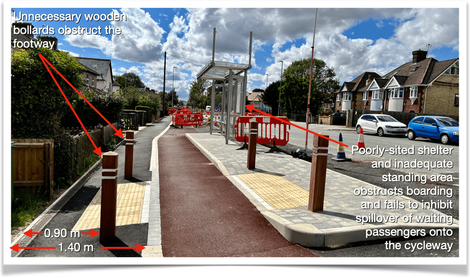
Seriously deficient, newly installed, island bus stop
Union Lane (inbound) 0500CCITY083 (Milton Road, Cambridge
Good points
A shelter, with integral seating, is provided, at the downstream end of the island.
The shelter has an integral pole and bus stop flag at the upstream end.
A lockable case for printed route/timetable information is provided.
Hopefully RTPI will be installed.
Deficient points
The width of the island is inadequate at 2.05 m. A user of a ‘reference wheelchair’ (DfT guidance) of 1.20 m length, mounting a 1.20 m manually-extended wheelchair ramp would need to reverse by approximately 0.50 m into the cycleway creating a collision hazard with cyclists.
Siting of the shelter, with its wall close to the carriageway, set-back approximately 0.50 m, unnecessarily restricts access to buses.
The distance, from the wall of shelter to the cycle lane, at 0.95 m, is inadequate and could lead to pedestrian spillover onto the cycleway at busy times.
The wall of the shelter should back onto the cycle track, not the carriageway, to facilitate boarding and to inhibit spillover of waiting passengers onto the cycleway at busy times.
The recommended 2.00 m unobstructed width of footway is not met, being only 1.40 m (where not obstructed by street furniture).
Unnecessary wooden bollards obstruct the footway and bus stop island, further reducing footway width from 1.40 m to 0.90 m.
What constitutes good design of bus stop infrastructure?
There should be hard-standing of sufficient area to accommodate queuing passengers and a minimum width (kerb-to highway boundary) of 2.50 m to accommodate a ‘reference wheelchair’ (DfT guidance) of 1.20 m length and the associated 1.20 m manually-extended bus-mounted wheelchair ramp to be deployed.
Where the hard-standing is not part of, or adjacent to a footway, it should be connected to a footway by a hard-surfaced path.
Shelters with integral seating should be provided wherever possible.
Kerb-adjacent shelters should be sited downstream from bus stop carriageway-markings, enabling queueing passengers to face the oncoming bus.
A bus stop flag should be fixed to the upstream end of the shelter to clarify where the boarding doors will be positioned.
For shelters set back at the edge of the highway boundary (eg close to a private wall) the foregoing two points are less essential.
There should be a lockable case for printed route/timetable information.
There should be no obstructions (eg litter bins, legacy bus-stop poles) for passengers boarding/alighting.
RTPI, of e-paper type, should ideally be installed in the shelter at the upstream end. Overhead displays should be integrally-mounted at the upstream end of the shelter, or pole-mounted around 2.50 m upstream from the shelter, for ease of visibility and to avoid boarding/alighting obstruction.
No other street furniture (eg lighting columns, litter bins) should be sited near the kerb-edge closer than 2.50 m from the boarding/alighting point.
Consideration should be given to the length of the bus stop carriageway markings, especially upstream of the boarding/alighting point to reduce the likelihood of obstruction by other vehicles and to facilitate simultaneous stopping of two buses on frequent services.
Bus operators should be consulted, at the earliest opportunity, on the proposed location of stops, their design and siting.
In addition to the above principles concerning infrastructure siting and design, our groups believe that the following principles should apply.
Bus stop islands – additional considerations
Design and siting characteristics should give consideration for those with a visual impairment, for all those with mobility impairments and for passengers with prams/pushchairs/buggies or those carrying heavy luggage.
Consultations should take place at the earliest possible stage between the Greater Cambridge Partnership, the Highway authority, bus operators and groups representing those with visual, mobility, hearing or cognitive impairment who may be most at risk when crossing a cycle path to access the bus stop.
Footway amenity should not be adversely affected by the installation of a bus stop bypass; 2.00 m unobstructed width of footway should be retained.
The passenger crossing-point should be clearly identified with blister tactile paving.
The crossing should have a contrasting surface delineated with either ‘Zebra’ stripes or ‘Pelican’-style dashed lines, be on a raised table, providing a level surface for bus passengers/pedestrians and those in wheelchairs to access the island, on the main identified pedestrian desire-line.
The cycle-track should rise to footway level on the approach to the crossing-point, through a smooth vertical change.
Other measures to encourage cyclists to reduce speed and to encourage courtesy from cyclists on the approach to the crossing-point should be incorporated, including on-cycleway markings and, possibly, a narrowing of the cycle track. However this should not compromise provision for non-standard cycles (eg ‘cargo’ bikes/trikes).
Sufficient space for a 1.20 m manually-extended wheelchair ramp to be deployed and for users of a ‘reference wheelchair’ (DfT guidance) of 1.20 m length to safely manoeuvre requires a minimum 2.50 m width for the island.
Good inter-visibility between cyclists and bus passengers must be achieved.
The wall of the shelter should back onto the cycle track, not the carriageway, to facilitate boarding and to inhibit spillover of waiting passengers onto the cycleway.
Any bus stop shelter advertising and information panels should be parallel to the carriageway and cycle track.
All other features of the shelter design should avoid blocking of sight lines.
[Note: Many of these points are drawn fromAccessible bus stop design guidance, Public Transport Team, Surface Strategy & Planning, Transport for London.]
Your views – send us some examples of good/poor bus stops
Text comments can be left in the comment box below.
If you would like to send us photographs, please email Cambridge Area Bus Users, after making your comment. Please attach photos (not documents into which photos have been inserted) and let us know which stop they show and to which comment they refer.
Significant changes to the University’s “Universal” (or “U”) service are taking place on Monday 2nd October.
Two distinct services are being created, to be known as “U1” and “U2”.
U1 is essentially the same as the extended version of the current service – the one that calls at Girton Corner (but only a very few times a day at present). Throughout most of the day alternate services will extend to/from Girton Corner, but otherwise follow the existing route (except that journeys towards Girton Corner call adjacent to Eddington Sainsbury’s and not across the road).
U2 takes a different route between Grange Road and Queen’s College, serving the whole of Grange Road and Barton and Newnham Roads between Grange Road and Silver Street. Omitting, therefore, West Road. Some U2 journeys extend to/from Girton Corner.
One other significant change is that weekend services will again serve the Biomedical Campus (as happened during the Covid pandemic).
Overall frequency remains unchanged. Services from the Biomedical Campus continue to serve Homerton College (and Hills Road more generally) whilst the northbound lane of the southern section of the Busway remains closed to buses.
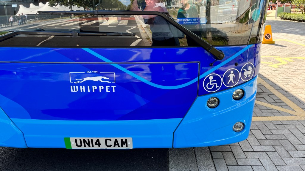
The service is operated by Whippet on behalf of the University of Cambridge.
The new timetable – and a handy route map for those unfamiliar with the area – is available from the Whippet website.