Bus Stops: The Good, The Bad, And The Ugly


Just an unremarkable stop. What’s special about that?

As caption and subsequent text
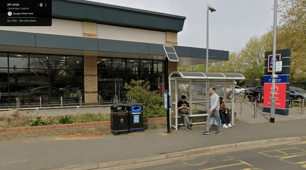
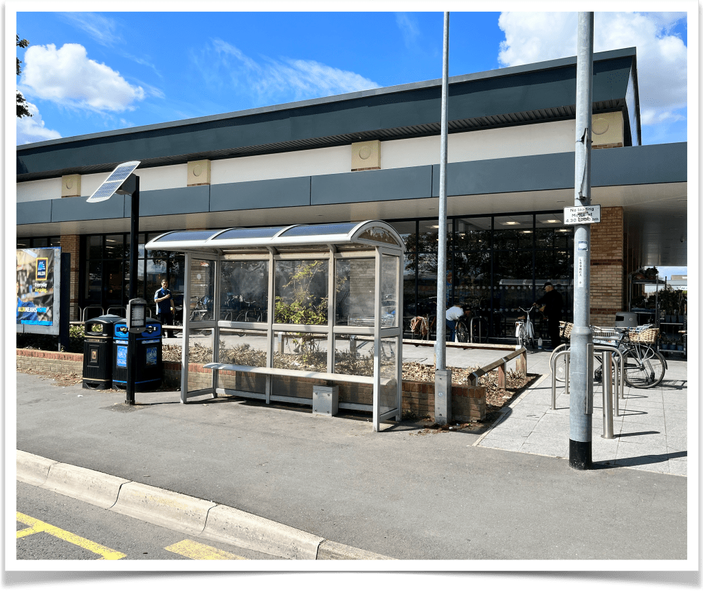
Stanley Road (outbound) 0500CCITY165 (outside Aldi, Newmarket Road, Cambridge). Click the image to explore on Google Maps.

At first glance this is an unremarkable stop. There are, however, a number of features which suggest that whoever commissioned and installed the infrastructure was actually thinking about the needs of bus passengers.

This stop is provided with a shelter, with integral seating, set back at the edge of the highway boundary. A bus stop flag has been mounted on an adjacent street-lighting column. Real-time passenger information, of e-paper type, powered by a solar panel, is installed close to the shelter at the upstream end. A lockable case contains printed route/timetable information. There are no obstructions for passengers boarding/alighting. Litter bins are well-sited. A raised kerb aids easy boarding/alighting, which is of particular benefit to wheelchair-using passengers and parents with children in buggies.


What’s so bad about that? There’s a shelter.

As caption and subsequent text
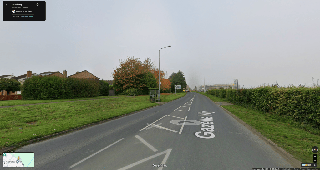
Eland Way (NaPTAN 0500STEVE013) towards Addenbrooke’s and city (left) and (NaPTAN 0500STEVE016) towards Tesco and Fulbourn (right) on Gazelle Way Fulbourn/Cherry Hinton. Click the image to explore on Google Maps.

Addenbrooke’s and city-bound passengers benefit from a shelter with integrated seating and hardstanding, whilst Fulbourn-bound passengers have no shelter. Both stops benefit from timetable cases, although the city-bound timetable is cunningly hidden the wrong side of the lamp-post. However neither stop could be considered accessible. Reaching the stop on the left involves slithering down a grassy bank; the stop on the right additionally involves the hazard of crossing a 40mph road with no pedestrian crossing.


Another one with a shelter? Are we being picky?

As caption and subsequent text
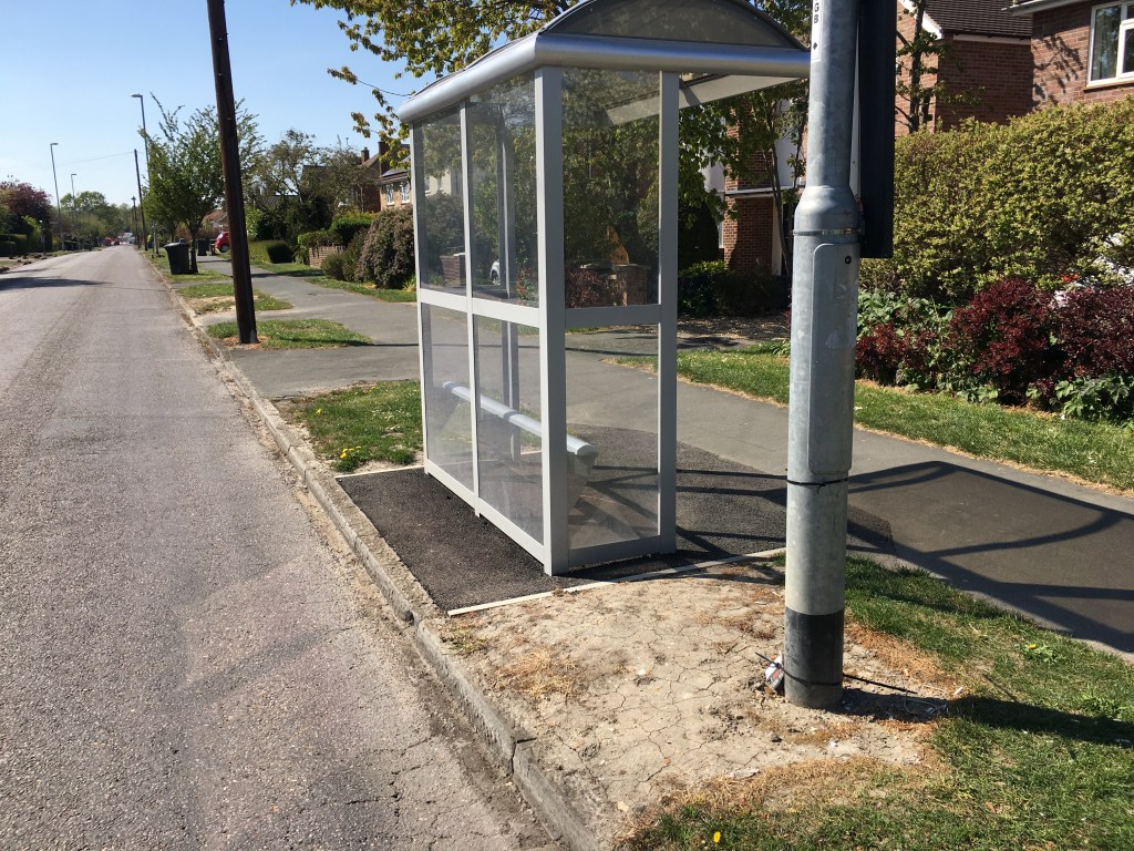
Almoners’ Avenue (NaPTAN 0500CCITY267) on Queen Edith’s Way towards Cherry Hinton. Click the image to explore on Google Maps.

There is, indeed, a shelter, with hardstanding and integrated seating, and a printed timetable in a locked case. However, neither the contractors nor whoever commissioned the infrastructure seem to have considered where passengers would board, or alight from, buses. The adjacent patch of parched, dry soil is fine for able-bodied passengers in good weather.

When that patch is wet, muddy and slippery, it is a hazard for all passengers, but particularly those using wheelchairs or other mobility aids.

PS: explore this stop on Google Maps. Should it now be in the ‘Ugly’ category?


Ah, point taken.

As caption and subsequent text
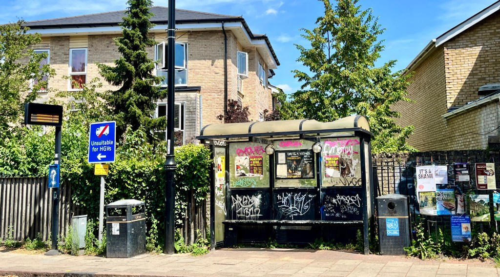
The bus stop infrastructure at Gwydir Street stop (towards Addenbrooke’s, NaPTAN 0500CCITY404) on Cambridge’s Mill Road. Click the image to explore on Google Maps.

The shelter has a broken roof, is covered in graffiti and fly-posting. The pole supporting the adjacent real-time passenger information display also hosts a timetable case, which is empty and graffitied. We are uncertain who is responsible for this shelter…


Responsibility for bus stops in the Cambridge area is split between various bodies. Here is brief digest:

  • Cambridgeshire County Council (the Highway Authority) is the body which has traditionally approved the siting of bus stops – although the Cambridgeshire and Peterborough Combined Authority is now the Transport Authority, so there are overlapping responsibilities.
  • Bus stop locations should then be entered on the National Public Transport Access Nodes (NaPTAN) database.
  • The Combined Authority and/or Highway Authority is responsible  for providing good hard-standing for bus stops; and should provide a bus-stop pole, unless an adjacent street-lighting column can be used.
  • Provision of a bus stop flag is, currently, the responsibility of the bus operator, as is a timetable case and printed timetable.
  • Real-Time Passenger Information displays (pole-mounted, integral within a shelter, or of the more modern, compact e-paper type), if provided, is the responsibility of the Combined Authority. The RTPI feed is operated by contractor Vix Technology on behalf of the Combined Authority.
  • Bus shelters are, generally, the responsibility of the lower-tier authorities (eg Cambridge City Council, South Cambridgeshire District Council) who may have agreements with advertising companies (eg Bauer Media Outdoor UK, formerly Clear Channel/JC Decaux) which provide and maintain some shelters (in return for the right to sell static or moving advertisements). Additionally Parish Councils may choose to install shelters and seating. (Good examples can be found in the Histon & Impington and Great Shelford parishes.)
  • However, when roads are re-modelled (Hills Road, Histon Road, Milton Road) using Greater Cambridge Partnership money it is unclear who has responsibility for design of siting of stop and shelters.
  • Cambridge Area Bus Users is not aware of the existence of any bus stop design manual published or followed by the Combined Authority to guide new installations, or programmes of improvement.

Cambridgeshire and Peterborough Combined Authority have a poor inheritance, from when Cambridgeshire County Council were the Transport Authority.

Back in April 2019, a (then) senior county councillor and (then) public transport officer, explained that:

Bus stop locations are the decision of the county council in consultation with bus operators and are then entered on the National Public Transport Access Nodes (NaPTAN) database. A pole may be provided where a convenient piece of street furniture, such as a street lighting column, is not available. It is the responsibility of the operator to mount their flag on the pole. Timetable frame and flag are installed by the bus operator. Only about half the stops have a flag, the rest are unmarked.

It was only on 15th November 2023, following public questions on behalf of Cambridge Area Bus Users, that the Cambridgeshire and Peterborough Combined Authority’s Transport & Infrastructure Committee agreed that:

(7.2.e) The CPCA would go through an options process to understand what was the right approach for a combined authority to take in regard to ownership and maintenance of bus stop infrastructure.

Translation: The Combined Authority know the locations of bus tops (from the NaPTAN database) but we’ve no real idea what’s installed at each location: pole? bus stop flag? timetable case?shelter? seat? Oh, and we don’t really know who installed what, still less who is responsible for maintaining what.

The Deputy Mayor at that time, Anna Smith, did promise that there would be a nominated officer charged with oversight of bus stop infrastructure. See: Transport & Infrastructure Committee Draft Minutes Wednesday 15th November 2023.


At the Cambridgeshire and Peterborough Combined Authority Transport Committee on 4th March 2026 a programme of Bus Stop Infrastructure Improvements was agreed.

To see if there are improvements planned for a bus stop which you use, read/download the Bus Stop/Shelter Infrastructure Improvements programme PDF produced by Systra for Cambridgeshire and Peterborough Combined Authority. The criteria for selection can be found in this report to the committee: Bus Stop/Shelter Infrastructure Improvements Report.


The October 2023 joint position paper from Cambridge Area Bus Users and Living Streets, Cambridge has a good summary of our views. Additional links are provided for those who would like to read more.


  • Our Executive Committee diligently report failures of the RTPI system – both of hardware and data.
  • We are looking, more strategically, on why some services do not seem to track, or to give a realistic estimate of bus arrival times.
  • A survey of printed information (or the lack thereof) at key locations is also being undertaken.
  • Our Executive Committee member for St Ives has worked with others to produce an information leaflet and vastly improved printed information in and around St Ives Bus Station.

All of these will form the subject of forthcoming posts.


Bus stop infrastructure

logos of Cambridge Area Bus Users and Living Streets Cambridge
Click the logos above to view down load the joint position paper

With thanks for advice from member groups of Cambridgeshire Sustainable Travel Alliance, including Camcycle


Too much bus stop infrastructure is poorly designed for queueing, boarding and alighting, especially disadvantaging passengers using wheelchairs, walking-aids, and parents with buggies.

Cambridge Area Bus Users has received numerous complaints about bus stop islands (‘floating’ bus stops). Some members are of the view that this type of bus stop should not be installed. However, as with all highway infrastructure, there are good examples and poor examples. (Unfortunately, we are still looking for a good example of a bus stop island in or around Cambridge.) And, just to scotch an ugly little rumour, the design and implementation of bus stop islands is not overseen by Camcycle. (We would like to know who does oversee the design and implementation of bus top infrastructure.) Poor design of bus stop islands creates problems for cyclists, bus passengers, and pedestrians alike, but particularly disadvantages people with disabilities.

And sub-standard bus stop infrastructure is prevalent in traditional stops, too.

But let’s start on a positive note, with some good-quality, recently-installed bus stop infrastructure.


Stanley Road (outbound) 0500CCITY165 (outside Aldi, Newmarket Road, Cambridge)

Good points

  • The shelter, with integral seating, is set back at the edge of the highway boundary.
  • A bus stop flag has been mounted on an adjacent street-lighting column.
  • RTPI, of e-paper type, is installed close to the shelter at the upstream end.
  • There are no obstructions for passengers boarding/alighting.
  • Well-sited litter bins do not obstruct pedestrians.
  • Overall installation gives good access to accommodate a ‘reference wheelchair’ (DfT guidance) of 1.20 m length and deploying the associated 1.20 m manually-extended bus-mounted wheelchair ramp.

Point for improvement

  • There should be a lockable case for printed route/timetable information. (This has since been installed.)

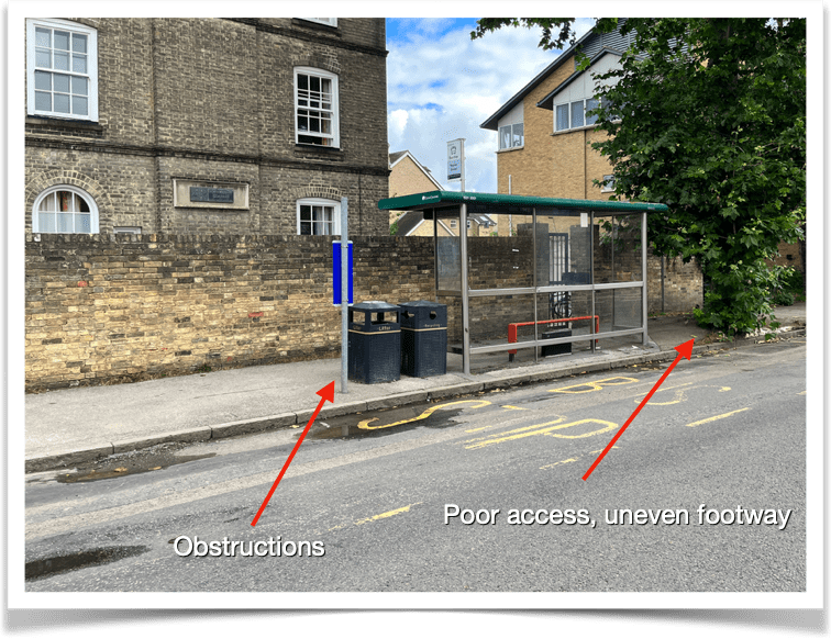
Napier Street (outbound) 0500CCITY102 (Newmarket Road , Cambridge)

Photo of Napier Street, Cambridge (outbound) 0500CCITY102
Details in subsequent text

Deficient points

  • The shelter is adjacent to the bus stop carriageway-markings. However boarding from the downstream end would be difficult because of a nearby tree, which ‘bushes’ near its base in the growing season.
  • At the upstream end of the shelter boarding/alighting is obstructed by a litter bin, a recycling bin and a redundant bus stop pole with no flag. (The bins have since been removed.)
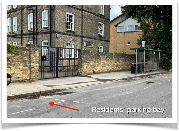
  • A nearby residents’ parking bay, upstream, prevents buses pulling in close to and parallel to the kerb, creating difficulties for boarding, especially for users of walking aids and wheelchairs.

Good points

  • A shelter with integral seating is provided.
  • Siting of the RTPI display is integral at the upstream end of the shelter.
  • There is a bus stop flag affixed to the upstream end of the shelter.
  • A lockable case for printed route/timetable information is provided.

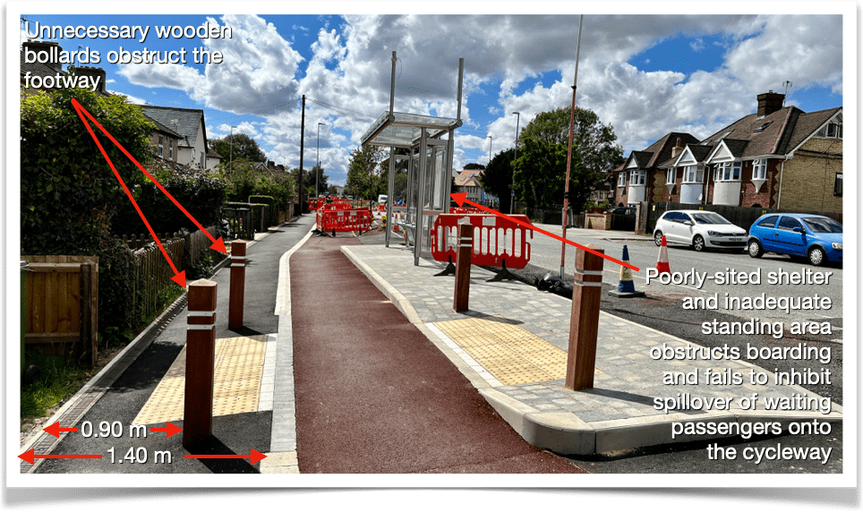
Union Lane (inbound) 0500CCITY083 (Milton Road, Cambridge

Good points

  • A shelter, with integral seating, is provided, at the downstream end of the island.
  • The shelter has an integral pole and bus stop flag at the upstream end.
  • A lockable case for printed route/timetable information is provided.
  • Hopefully RTPI will be installed.

Deficient points

  • The width of the island is inadequate at 2.05 m. A user of a ‘reference wheelchair’ (DfT guidance) of 1.20 m length, mounting a 1.20 m manually-extended wheelchair ramp would need to reverse by approximately 0.50 m into the cycleway creating a collision hazard with cyclists.
  • Siting of the shelter, with its wall close to the carriageway, set-back approximately 0.50 m, unnecessarily restricts access to buses.
  • The distance, from the wall of shelter to the cycle lane, at 0.95 m, is inadequate and could lead to pedestrian spillover onto the cycleway at busy times.
  • The wall of the shelter should back onto the cycle track, not the carriageway, to facilitate boarding and to inhibit spillover of waiting passengers onto the cycleway at busy times.
  • The recommended 2.00 m unobstructed width of footway is not met, being only 1.40 m (where not obstructed by street furniture).
  • Unnecessary wooden bollards obstruct the footway, further reducing footway width from 1.40 m to 0.90 m. (The bollards on the footway have since been removed.)

Read on, or download the Joint position paper from Cambridge Area Bus Users and Living Streets Cambridge PDF here.


  • There should be hard-standing of sufficient area to accommodate queuing passengers and a minimum width (kerb-to highway boundary) of 2.50 m to accommodate a ‘reference wheelchair’ (DfT guidance) of 1.20 m length and the associated 1.20 m manually-extended bus-mounted wheelchair ramp to be deployed.
  • Where the hard-standing is not part of, or adjacent to a footway, it should be connected to a footway by a hard-surfaced path.
  • Shelters with integral seating should be provided wherever possible.
  • Kerb-adjacent shelters should be sited downstream from bus stop carriageway-markings, enabling queueing passengers to face the oncoming bus.
  • A bus stop flag should be fixed to the upstream end of the shelter to clarify where the boarding doors will be positioned.
  • For shelters set back at the edge of the highway boundary (eg close to a private wall) the foregoing two points are less essential.
  • There should be a lockable case for printed route/timetable information.
  • There should be no obstructions (eg litter bins, legacy bus-stop poles) for passengers boarding/alighting.
  • RTPI, of e-paper type, should ideally be installed in the shelter at the upstream end. Overhead displays should be integrally-mounted at the upstream end of the shelter, or pole-mounted around 2.50 m upstream from the shelter, for ease of visibility and to avoid boarding/alighting obstruction.
  • No other street furniture (eg lighting columns, litter bins) should be sited near the kerb-edge closer than 2.50 m from the boarding/alighting point. 
  • Consideration should be given to the length of the bus stop carriageway markings, especially upstream of the boarding/alighting point to reduce the likelihood of obstruction by other vehicles and to facilitate simultaneous stopping of two buses on frequent services.
  • Bus operators should be consulted, at the earliest opportunity, on the proposed location of stops, their design and siting.

In addition to the above principles concerning infrastructure siting and design, our groups believe that the following principles should apply.


  • Design and siting characteristics should give consideration for those with a visual impairment, for all those with mobility impairments and for passengers with prams/pushchairs/buggies or those carrying heavy luggage.
  • Consultations should take place at the earliest possible stage between the Greater Cambridge Partnership, the Highway authority, bus operators and groups representing those with visual, mobility, hearing or cognitive impairment who may be most at risk when crossing a cycle path to access the bus stop.
  • Footway amenity should not be adversely affected by the installation of a bus stop bypass; 2.00 m unobstructed width of footway should be retained.
  • The passenger crossing-point should be clearly identified with blister tactile paving.
  • The crossing should have a contrasting surface delineated with either ‘Zebra’ stripes or ‘Pelican’-style dashed lines, be on a raised table, providing a level surface for bus passengers/pedestrians and those in wheelchairs to access the island, on the main identified pedestrian desire-line.
  • The cycle-track should rise to footway level on the approach to the crossing-point, through a smooth vertical change.
  • Other measures to encourage cyclists to reduce speed and to encourage courtesy from cyclists on the approach to the crossing-point should be incorporated, including on-cycleway markings and, possibly, a narrowing of the cycle track. However this should not compromise provision for non-standard cycles (eg ‘cargo’ bikes/trikes).
  • Sufficient space for a 1.20 m manually-extended wheelchair ramp to be deployed and for users of a ‘reference wheelchair’ (DfT guidance) of 1.20 m length to safely manoeuvre requires a minimum 2.50 m width for the island.
  • Good inter-visibility between cyclists and bus passengers must be achieved.
  • The wall of the shelter should back onto the cycle track, not the carriageway, to facilitate boarding and to inhibit spillover of waiting passengers onto the cycleway.
  • Any bus stop shelter advertising and information panels should be parallel to the carriageway and cycle track.
  • All other features of the shelter design should avoid blocking of sight lines.

[Note: Many of these points are drawn from Accessible bus stop design guidance, Public Transport Team, Surface Strategy & Planning, Transport for London, January 2017.]


If you would like to send us comments and/or photographs, please email Cambridge Area Bus Users. Please attach photos to the email (not documents into which photos have been inserted) and let us know which stop they show.